
This unit of study is designed to generate increased student awareness of the significe of the Tidal Schuylkill River and its role in our daily lives. All but one of the five lessons require the use of technology; smart boards, chrome books or laptops. These lessons are highly interactive and will prompt students to think more about the human impact on the environment, particularly our rivers, creeks and streams. Through the use of interactive web based programs and YouTube videos students will learn the urban water cycle.
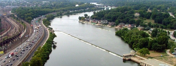
Currently, there is no mention of the Schuylkill River in any component of the Philadelphia School District’s science curriculum. Not even in the course entitled environmental science. I desire to expose and familiarize or reacquaint students to this body of moving water that runs through the city of Philadelphia. A river is defined as “a natural flowing watercourse, usually freshwater, flowing towards an ocean, sea or another river”. The water in rivers comes from rain, snow and sometimes from underground streams. Left to nature a river forges its own boundaries, and they change over time. However, humans have often chosen to establish fixed boundaries and define rivers by lines on a map, as Dilip daCunha shows–and by building dams, canals, and concrete embankments. This unit of study will foster a since of concern and caring about the river. This series of lessons attempts to encourage students to view the river as a community resource in much the same way they see their local recreational center. Among one of the specific outcomes of this curriculum, unit is to stimulate students to have a sense of consciousness about the Tidal Schuylkill River. Hoping this may lead students to some sort of civic action in support of the river. To accomplish this, students will participate in various learning activities that explore what I am calling “river science.” Students will also read articles about the river and its socioeconomic, political, and ecological dimensions. As we learn about the river we will continuously be asking ourselves: is the river alive? At its heart, this unit of study will be interdisciplinary and cross-curricular, incorporating anthropology, social studies, literature, and math as well as science. It also explores concepts related to geography, topology, map reading, and earth science. And of course, a unit of study about a river must address ecology and climate change. After completing these lessons students will know where our drinking water comes from and where our wastewater goes. Students will also learn when the river is safe for various recreational activities. A.P. Randolph is a career and technical high school with a combined mission to prepare students for entry-level careers in technical fields such as welding, auto mechanics, building trades, and health-related technologies as well as for college. It is with our mission in mind that this unit of study guides students in doing scientific analysis of the river as well as in reading and responding to interdisciplinary articles, book chapters, and poetry that explore how the river has been and is being used—and how the river is affected by these uses. An Aerial view of the river along the drive (Philadelphia Water Department) For many students, even those who live in proximity to it, the river is a mystery. It is only thought of in passing. This unit of study will bring the river into the forefront of a series of lessons and activities designed to give students a sense of consciousness about the Schuylkill. Although A.P Randolph is not a magnet or special admit school our student population is drawn from all over the city. An analysis of A. P. Randolph’s demographics reveals that of the 361 students currently enrolled, 37.1% are chronically truant and 83.9% are chronically tardy. The student population is 97% African American and 3% other. 22.2% of the student body are special education students with individualized educational programs. 23.5% of our students scored proficient and advanced on the Keystone literature exam, 8.6% scored proficient and advanced on the Keystone algebra exam, but only 2.4% scored proficient and advanced in science. One of the obstacles to our students performing well on the Keystone science exam is that they have to respond to constructed response items. Constructed response items are written scenarios that require students to make a written response. Constructed response items are written scenarios that require students to make a written response. They are graded on the merit of thoroughness. Our students often do not even attempt these questions, and consequently they score poorly. However, they do respond well to the multiple choice and true or false components of the assessment. One of the aims of this unit will be to provide students with opportunities to improve their critical thinking and writing skills, to improve their performance on the Keystone science exam. Various teaching strategies will be used to teach the content in this unit including but not limited to, whole class instruction, cooperative learning, small group instruction, computer-aided instruction, discovery learning, and hands-on laboratory instruction. Also, focused reading in the form of directed reading and writing in-class assignments will be utilized to improve students’ ability to respond better to the constructed response items on the Keystone science exam. Through participation in this curriculum unit, students will also improve their ability to responds to critical thinking questions on the Keystone Science Exams. These are end –of-year assessments that are given in ninth grade Algebra 1, Literature and Biology. We will be addressing a wide range of assessment anchors while adhering to guidelines for eligible content as it relates to science instruction. The Schuylkill River got its present name, meaning, “hidden river,” from Dutch settlers who discovered its mouth hidden behind the Delaware River’s League Island, (Catalano and Zwikl, Along the Schuylkill). The Schuylkill River is a tributary of the Delaware River, flowing 128 miles from its headwaters in Pottsville to where it joins the Delaware, at Philadelphia at the site of the former Philadelphia Navy Yard (Guest, Mafiadoc.com, n.d.). From the confluence, the river is navigable for 7.3 miles to Fairmount Dam. This stretch of the river is tidal. A federal project provides for a channel 33 feet deep to the Passyunk Avenue Bridge, 26 feet deep to Gibson Point, and 22 feet deep to the University Avenue Bridge. Many heavy industries historically grew and flourished along the river from its headwaters to the debouchment into the Delaware: the coal industry, the iron, and steel industry, the railroad as well as oil refineries. These industrial entities have had some profound impacts on the river. Click onto the following link for a comprehensive oral summary of the history of the river. https://www.youtube.com/watch?v=lMEMxe6B4CY In the decades around 1800s the Pennsylvania Legislature approved a charter for the Schuylkill Navigation Company to build a navigation system of canals, dams and slack water pools from Mill Creek, just north of Pottsville, along the river to Philadelphia (O’Rourke). They built 120 locks and the first ever canal tunnel. In 1819 the city completed negotiations to build and maintain the dam and lock system and to develop a waterworks to improve the water supply to the city. The last commercial cargo was transported in 1931. As we move forward in time many sections of the vast canal system have undergone restoration to promote recreation and celebrate the past. Currently, the Philadelphia Water Department is preparing to move forward on a project to restore water flow to the Manayunk Canal. The city Parks and Recreation Department plans to restore the canal’s lower locks chambers used to adjust water levels so boats can travel up and down the river (Melamed S. Saving the Canal, Phila. Inquire March 2019). The Schuylkill remains today a vital source of municipal water for Philadelphia. Since 1999, the creation and expansion of the Schuylkill River Trail afford increasing recreational opportunities along and even on the river. Our area of interest is in the Lower Schuylkill, often referred to as the tidal Schuylkill, because the ocean influences the direction of flow and water levels. Twice a day, when the tide comes in, water flows upriver from the Delaware River toward Fairmount Dam. The water level can fluctuate by 6 feet between high and low tide. The tidal Schuylkill is home to 40 species of fish (Fishing at the Schuylkill River (Tidal – South Street to Fairmount Dam). Depending on the season and river conditions the river is home to, catfish, perch, carp, bass, shad, and eel and a wide variety of other marine life. There is no regular stream of water quality data for this section of the river where there are 164 combined sewer overflows (CSOs). The Philadelphia Water Department does maintain CSOcast which is a public notification system to alert the public of possible Combined Sewer Overflows from Philadelphia’s combined sewer system outfalls. To learn more, click on the following link: http://www.phillywatersheds.org/what_were_doing/documents_and_data/live_data/csocast We ask a lot from our river, and the uses humans have made of the river have competed not only with other species’ uses and needs but have benefited some humans and harmed others. The Schuylkill has been used and is used to provide drinking water, fish for food, transporting people and goods by boat. In the past, the river has been used to turn machineries such as water mills and turbines. Many leisure activities and sports such as swimming, boating, and fishing also take place on the river. The author enjoys simply walking the trails or just sitting by the river. There are many scenic spots along the banks of the Schuylkill. The Schuylkill also has been the subject of many painters, storytellers, and poets. Click onto the following link, https://www.youtube.com/watch?v=3xwLWbfc3YI The Schuylkill River is the site of the development of the nation’s first public water supply. Since 1801 the Philadelphia Water Department has provided water to the community. Philadelphia established a city-owned and financed water supply system after a series of yellow fever epidemics killed thousands of people in the late eighteenth century. Water is piped throughout the city using direct lines to the homes and businesses of paying residents. Hydrants and public water fountains provide free water. The city’s first system was powered by a steam engine, located at what is now City Hall; a second engine at the foot of Chestnut Street drew water from the Schuylkill River. This system frequently malfunctioned and was very unreliable. In 1815 a new waterworks was opened. Steam engines pumped water into reservoirs located on top of Fairmount, a hill, and the site today of the Philadelphia Museum of Art. The steam engines proved too costly, so a plan was developed to use waterpower to pump water into reservoirs. Between 1819 and 1821 the Fairmount dam was built across the Schuylkill to direct water to a Mill House with three water wheels that replaced the steam engines. The dam cut diagonally across the river and channeled water into the waterworks. Since the Schuylkill is a tidal river, the dam also prevented brackish water in the Delaware River from mixing with the fresh water (Videosporalex, 2017). The Fairmount water works closed in 1909 (Wikipedia). Click on to the following link to see a video of the Fairmount Dam located at the Water Works on the Benjamin Franklin Parkway: https://www.youtube.com/watch?v=8fDsosL4RgY Today, the Philadelphia Water Department (PWD) maintains 3,000 miles of sewers, 79,00 stormwater inlets, three water treatment plants, three wastewater treatment plants, over 25 pump stations, 175 CSO regulating chambers, 164 CSO outfalls, over 3,000 miles of water mains, 19 reservoirs, five water storage tanks and over 450 stormwater outfalls. Philadelphia’s water supply stem and distribution system serve nearly a 130-square-mile area (“Water Infrastructure Management,” n.d.). Our drinking water treatment plants draw water from the Schuylkill and Delaware rivers and process the river water through numerous testing and treatment stages to make the water drinkable. PWD then distributes the water to approximately 1.5 million Philadelphia residents through more than 3,000 miles of water mains [1]. Fairmount Water Works Park (Susan Candelario) The PWD operates three drinking water treatment plants: Baxter, Belmont and Queen Lane located in proximity to the Schuylkill and Delaware Rivers. The PWD’s wastewater and stormwater conveyance system is divided into three drainage districts Northeast, Southeast, and Southwest. Each district conveys flow to its respective wastewater treatment plant through a network of various components. The wastewater system is composed of brick, concrete and vitrified clay piping. The pipes range from 8 inches to 22 feet in diameter and are circular, rectangular or egg-shaped. The system is about 50% brick, 25% vitrified clay and 25% concrete pipe. The infrastructure components of the wastewater and stormwater conveyance system include branch sewers, trunk sewers, combined sewer interceptors, separate interceptors, and storm relief sewers. Branch sewers collect wastewater from lateral connections from homes and businesses and the wastewater flow goes to a treatment plant. Combined sewer interceptors convey flow from storm relief diversion chambers to the receiving waters during extreme high flow. When it rains, and the volume of combined stormwater and wastewater is larger than the combined sewer systems’ capacity the mixed stormwater and wastewater are discharged into the city’s stream at a combined sewer outfall (CSO) before it is treated. When the combined sewer system experience higher than normal volume flows, the relief system, CSO allows discharges containing human waste and industrial waste to flow into the Schuylkill. In the separate sewer system, stormwater is discharged directly to a stream. As the stormwater runs of the pavements and streets pollutants are also carried into the streams[2]. Philadelphia Water Treatment Facility Please click on the following link for the video, How a water treatment plant works: https://www.youtube.com/watch?v=0_ZcCqqpS2o Please click on the following link for, How a wastewater treatment plant works: https://www.youtube.com/watch?v=FvPakzqM3h8 Since the river became the first scenic river designated in Pennsylvania there is a growing number of profit and non-profit organizations providing recreational and educational activities in and along the Schuylkill River and the Schuylkill River Trail (n.d.). One such origination is the Schuylkill Banks, operated by the Schuylkill River Development Corporation. They are a non-profit organization whose mission is to revitalize and transform the tidal Schuylkill corridor to benefit the Philadelphia community Click onto the link and go to their website, https://www.schuylkillbanks.org/about. Another such organization is the Schuylkill River and Urban Waters Research Corps Archive. It’s a collaborative research collective initiative managed by the Penn Program in Environmental Humanities. Click on to the following link http://www.schuylkillcorps.org/. One of the most fascinating organizations providing educational and recreational opportunities focused on the Schuylkill is the Fairmount Water Works. It is actually a branch of the public affairs department of the Philadelphia Water Department. They offer numerous educational programs to forester care and concern for Schuylkill Water Shed, click onto the following link: http://fairmountwaterworks.org/ Climate change is the result of global warming, sometimes referred to as the greenhouse effect. The major cause of climate change is human combustion of fossil fuels. Burning fossil fuels releases large amounts of CO2 into the atmosphere. Carbon dioxide, along with other greenhouse gases absorb infrared radiation, and creates a virtual blanket over the earth’s surface, keeping it warmer than it would naturally be (Houghton J. 2005). NASA provides evidence for rapid climate change on its website GLOBAL CLIMATE CHANGE, click onto this link for in depth information: https://climate.nasa.gov/evidence/ According to the Philadelphia Water Department (“Water Infrastructure Management,” n.d.) “The impacts from climate change in Philadelphia include more rain, extreme storms, higher temperatures, rising sea levels, and possibly drought”. As a result of higher air temperatures, the temperature of the Schuylkill has also risen, and these higher water temperatures can create a situation where bacteria growth is accelerated and oxygen levels for aquatic life decrease. Rising sea levels could alter the salt line separating the freshwater from the Delaware River and the saltwater from the Atlantic Ocean. There is the potential that saltwater may gradually flow upstream and have an impact on our drinking water treatment process, as the Schuylkill is our source for drinking water. Furthermore, with more rain, more stormwater runoff is generated. This increased runoff negatively affects the Schuylkill, stresses the drainage system and degrades the streambank. Another noticeable effect of climate change on the Schuylkill is increased flooding. As we experience extremes in weather brought on by climate change seasonal droughts have occurred. When these droughts occur the river flows and available water supply is reduced, the salt line has the potential to advance up the Delaware and the growth rate of algae may accelerate (PWD, 2017). Click on the link to see what happens after heavy rains (40 sec). https://www.youtube.com/watch?v=uvssZTvmiaw Students will view the river from various perspectives. Essentially we want our inner-city students to think about the river and its value and impact on our daily lives. We intend to do this using an interdisciplinary approach in the science classroom. They will learn of our interdependence on the river, it is our source of drinking water; as well a waste disposal site in addition to being used for recreational activities. After completing this series of lessons students will be able to respond to, “who is responsible for the river?” Lessons 1 ask students to think about what happens when we pour something down the drain, or flush a toilet, where does it go, and how does it get there? Students will use the educational web site Phillyh2o.org to get an in-depth understanding of our sewer system. Lesson 2 asks students to think about where the water we use in our homes come from and how much do we use. Students will gain an understanding of how much water we use in our daily lives in lesson 2 by navigating the interactive web-based program, the Water Foot Print Calculator. Lesson 3 is intended to increase students’ awareness of the problem of pollution, something we can do something about. In lesson 4 students will learn water quality analysis by using Philly RiverCast, a web-based daily forecast of Schuylkill River water quality in Philadelphia delivered on a site provided by Philadelphia Water. Lesson 5 takes us out of the classroom for an intimate and up-close look at the river. (GRADES 6-12) Writing in Science and Technical Subjects Writing; Students write for different purposes and audiences. Students write clear and focused text to convey a well-defined perspective and appropriate content. Grades 9-10 CC3.6.9-10.A. Write arguments focused on discipline-specific content CC.3.6.9-10.C CC.3.6.9-10.D CC.3.6.9-10.E CC.3.6.9-10.F CC.3.6.9-10.G CC.3.6.9-10.H CC.3.6.9-10.1 PA Academic Standards for Science and Technology 3.1.10. Grade 10 Describe patterns of change in nature, physical systems and man-made systems. 3.2.10 Grade 10 Apply knowledge and understanding of the nature of scientific and technological knowledge Apply the elements of scientific inquiry to solve problems. Identify and apply the technological design process to solve problems PA Common Core (High school mathematics) 9-12.CC.2.2.HS.D.9 Use reasoning to solve equations and justify the solution method. [1] This section draws extensively from the Infrastructure Management | Philadelphia Water Department, website [2] This section draws extensively from the Infrastructure Management | Philadelphia Water Department, websiteProblem Statement
Background
A brief discussion of the Schuylkill River
Competing Uses of the River
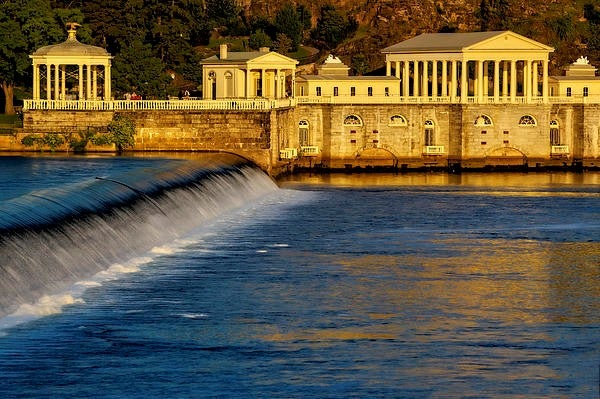
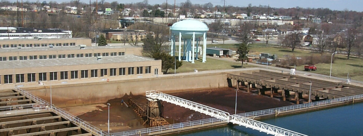
The Schuylkill: Our Source of Drinking Water
Wastewater and Stormwater
The Schuylkill: A source for education and recreation
Climate change and its effects on the Schuylkill River
Content objectives
PA Common Core Standards
Whole class instruction: In the article Exploring the Value of Whole Group Instruction in the Classroom, Derrick Meador (ThoughtCo. 3,28, 2018), defines whole group instruction as direct instruction using traditional textbooks. Typically in this mode of instruction, a teacher will stand in front of the classroom attempting to engage all students simultaneously. One of its drawbacks is that it often does not lend itself to differentiation. This can be compensated for when we move to the small group instruction mode however it is a valid way to introduce new material as well as basic material to every student at the same time. Studies show that all students benefit from whole-class instruction whether overt or covert (Flieller A. Jarlegan A., Tazouti Y. 2016). In my teaching situation, there is a need to also provide small group instruction; it is an opportunity to provide differentiated instruction. Many students are reluctant to ask questions during whole class instruction even when they don’t fully understand what was presented (n.d.). Small group instruction provides the teacher with an opportunity to rearticulate the content, and the student an opportunity to ask questions in a more personalized instructional interaction. In this mode of instruction, it is quite all right to repeat the main instructional objectives of the lesson presented. However one of the drawbacks to providing small group instruction is managing the other students in the classroom as you work with the small group (“Exploring “Math Talk” in Math Problems for 2nd Grade, And Beyond,” 2018). You must keep them on task as you circulate through the classroom. This can be accomplished by providing students with a silent reading assignment that requires a written response after the reading, or an activity related to reinforcing the concepts presented during the whole class instruction, lesson. Cooperative learning is an instructional method where students work in small groups to help each other master the academic content. Students participating, work with each other to make sure that everyone in the group understands the learning objective (Slavin 1995). There have been many studies researching the effectiveness of cooperative group learning in the science classroom. In a study conducted by Ozgecan Tastan Kink and Yezden Boz, the results showed that compared to traditional dyadic instruction, cooperative learning enabled a better understanding of concepts and improved student’s motivation (Chem. Educ. Res. Pract. 2012 13,221-236). Researchers in STEM education (science, technology, engineering, and math) have found that small cooperative group learning can improve student learning. In 1995 Felder and in 1998 Felder and Dietz concluded that higher academic performance and interest levels were achieved compared to traditional instruction alone when included in the instructional process. We will make use of technology in the classroom as often as possible. In some lessons, students will view materials on the computer screen or “Smartboard” rather than receiving written handouts. Computers provide access to enriched multi-media venues. We will make several virtual visits to the Schuylkill River in this curriculum unit. In our diverse classroom, students who are visual learners will have the opportunity to focus on the video content of a particular lesson. When using the computers at their desks, students can pause, or repeat portions of the video. This may provide some students with an opportunity to better understand the content of the lesson or activity. The use of technology will enable us to access enormous amounts of information regarding the river and get close to the river from our classrooms. “Discovery learning is an approach to learning in which the learner is allowed to explore and become actively engaged with concepts, objects or the physical environment to develop their understanding of it” (Wallace S. 2015). Students will participate in instructional activities that require them to answer questions that even the teacher does not know the answer to. This is true discovery learning; both teacher and student will “ discover” the answers by doing the activity. This mode of instruction may also be called activity-based instruction. This instructional strategy emphasizes that learning is a direct outcome of the “doing”. It is a form of experiential learning in which the learning outcomes are to be achieved by going through the process of completing the proposed activity. Newspaper articles, online articles and textbook readings will be used to prompt students to discuss issues about the Schuylkill River. As students are assigned various readings they will be asked to key in on certain passages to reflect on. After discussing issues orally students will be asked to write their responses. In a research review on the benefits of homework published by the Center for Public Education, it is suggested that there is no statistical link between homework and improved student achievement (Cooper 1989a). Our assignments will be optional and assigned specifically for student enrichment. Another intent of extended reading and writing homework in this unit is to provide students with independent practice in reading and comprehension. Students will have the opportunity to evaluate information and formulate their own opinions on issues related to the Tidal Schuylkill and climate rise as it relates to our city.Small group instruction
Cooperative learning
Computer-aided instruction
Discovery learning
Hands-on laboratory instruction
Focused Reading in the form of Directed Reading and Writing
Extended Reading and Writing Homework
Aim: (1) To gain an understanding of how our sewer system was developed. (2) To summarize research and historical information compiled and presented by Adam Levine, Historical Consultant for the Philadelphia Water Department Equipment: SMART board, chrome books Objectives: After completing this series of lessons and activities students will be able to: Introduce this lesson by asking students where does the stuff we pour down the drain go? If possible arrange to walk around the block your school is located on. You are counting the number of sewer drains and looking to see if they are cluttered or free of debris. Ask students what happens when the sewers are covered with leaves and trash. Once back in the classroom on your smartboard show students, how a waste water treatment plant works: https://www.youtube.com/watch?v=FvPakzqM3h8 Procedure: Introduce the vocabulary of “ FROM CREEK TO SEWER”. Allow students to use the Internet to find the definitions or use the whole group instructional technique and look up the words together using the SMART board. After reviewing this new vocabulary with students, click on the link, to watch an introductory video clip by Adam Levine which will serve as a prelude to this lesson: https://www.youtube.com/watch?v=Hcr6wBn-gE8 (3:23 min) After viewing Mr. Levine’s introduction, click on to the Philly h2o website which will serve as the content for this lesson: http://www.phillyh2o.org/creek.htm. Vocabulary: contour…silt…refuse…picturesque…utility…exigencies… encapsulated…topography…hydrology… culverted…deleterious…obliterated Ask students to read the opening paragraph, either read aloud to students or ask for volunteers to do the oral reading. (This is done so that every student at least hears what is written). After reading the first paragraph as students to: Check for understanding? Ask students to interpret in their own words what is the author trying to convey when he writes: “In this process, old landmarks and ancient contours are not respected, the picturesque yields to utility, and the face of nature is transformed to meet the exigencies of uniform grades, levels, and drainage”. Give students ample time to process their thoughts. First, ask students to share out loud their interpretations, and then ask them to write their interpretations down. Math extension: Direct students to click on “ Philadelphia’s Historic Streams”. Ask students to count the number of streams they see and record that number. You may want to show this on the smartboard as well and count them aloud with the class (I count 43 streams.) Now direct students to click on “ Philadelphia’s Remaining Streams”. Ask students to count the number of streams. (I count 21 streams) Ask students to determine what percentages of streams are remaining: Student calculations should go as follows: Originally there were 43 streams all but 21 have been culverted. 21 Remaining streams/ 43 Historic streams x 100%= 48.88% remaining Direct students to click on the third map. What do the red lines indicate on map #3? Students should realize that these red lines indicate the sewer pipes that the streams are encapsulated in. After completing this portion of the lesson we are ready to continue reading for understanding. We will read each paragraph together, aloud and respond to “check for understanding” questions as we go along. It is a good idea to ask for volunteers to read and join in with the reading. (This is called modeling) Paragraph 1: Discussion questions (1) Why do many histories of human settlement tend to overlook the alterations in the landscape that made settlement possible? Possible Response: Because changes in topography and hydrology are usually hidden beneath the development that follows them. Paragraph 2: (1) How long is the city’s drainage system? Possible response: The city’s drainage system is 3,000 miles. (2) What is meant by combined sewers? Possible answer: Combined sewers carry raw sewage along with the stream flow and stormwater runoff. Paragraph 3: Discussion questions (1) What was one of the main reasons urban streams were used for sewage disposal and ultimately as the beds for actual sewers? Possible Answer: It was standard practice for 19th and 20th-century engineers (2) When a section of the Cohocksink Creek in Philadelphia was “culverted” in 1860, The Board of Health stated, “The sanitary value of the change effected by the culverting of this creek is above price.” To respond to this question students should go back to paragraph 3 and find where it states “For years this natural tributary of the Delaware…has been a prolific source of miasma.” Paragraph 4: Discussion questions (1) Why did proper sewerage and drainage become such a major concern in Philadelphia? Possible Answer: Philadelphia was experiencing epidemic diseases thought brought on by unsanitary conditions. (2) Why did city engineers begin planning the culverting of creeks in advance of development? Possible Answer: Culverting the streams before they became polluted was seen as a positive step to protect public health. Paragraph 5: (1) What is the benefit of placing sewers in the natural stream valley? Possible Answer: By placing sewers in the natural stream valleys, the engineers were able to benefit from gravity flow. This also eliminated the high cost of deep excavations. (2) What other costs were avoided as well? Possible Answer: The cost of pumps and fuel were avoided in addition to the cost of building a bridge each time a street crossed the stream. Paragraph 6: Discussion questions (1) What advantage did building sewers in advance of development provide engineers? Possible Answer: It gave engineers more freedom in their designs. Paragraph 7: Discussion questions (1) How did building sewers in advance of development aid real estate developers, as well as benefit the city? Possible Answer; Real estate developers were able to sell their lots more easily because of the ready-made infrastructure provided by the city. And the city received a quick return on its investment in infrastructure from the increase in tax revenue from the new buildings. Paragraph 8: Discussion questions (1) How long did it take the Mill Creek conversion from creek to sewer to take place? Possible Answer: It took more than twenty-five years. (2) How long did it take for the burying of both branches of the Wingohocking Creek? Possible Answer: It took about 40 years After completing the reading of FROM CREEK TO SEWER and responding to the suggested discussion questions from each paragraph engage students in a conversation about the web-based article. Ask students if they live near a creek. Extended Reading and Writing; ask students to summarize Mr. Levine’s article and to take a position on burring streams and creeks. Is there an alternative? Extension: Go on to the Philly2o website and visit: DOWN UNDER, and MAPS for exploratory learning. Do you live near a historic creek? Introduce this lesson by asking students where does the water come from that they use at home and and how does it get to their homes? Remind students that the river is our source of drinking water. Show students how a water treatment plant works: https://www.youtube.com/watch?v=0_ZcCqqpS2o Aim: To determine “ What’s your water footprint?’ (How much water my family and I use). Materials and equipment: A smart board and individual chrome books. Objectives: After completing this series of lessons and activities students will be able to: Use the WATER FOOTPRINT CALCULATOR to determine their individual water usage as well as their household usage. Preparation: In this lesson, students will use a web-based water education program to determine the amount of water that they and their family use on a daily, weekly, monthly and yearly basis. It would be good if you had the opportunity to navigate through the program before attempting the lesson. After completing the entire program students will be asked to select what they are most interested in. Direct them to select “GETTING MY WATER FOOTPRINT”. They will then be asked to select “What do you most want to learn about? Direct them to select “INDOOR WATER USE”. Now they will see their individual usage and their household usage and the average US usage of gallons per day. Direct students to click on the WATER FOOTPRINT CALCULATOR: https://www.watercalculator.org/wfc2/ Click: GET STARTED. Respond to the questions honestly to get accurate results regarding your water usage. Give students ample time to respond to the questions about their direct water usage. When they reach the virtual water use page they will see their calculated direct water use. Virtual water use is the water that goes into making the food you eat, the things you buy and the energy you use. Click NEXT. After completing the WATER FOOTPRINT CALCULATOR program have students share out their individual and household usage results. Math Extension: Have students graph their collective data. Use these graphs to discuss trends in usage. Have students total the entire class’s individual and household usages and compare the collective average total with the national average. Remind students that we get our drinking water from the Schuylkill River. Extended Reading and Writing: Ask students to scroll down to review their water usage. As they scroll down on the right-hand side they will see TIPS on the left-hand side they will see items. Ask students, how many of these water saving tips can they implement in their homes. Ask students to do them for a week and write a short essay reveling tips they chose and the results of their choice. Teachers, besides using the calculator you may also want to explore the various links along with the header, such as EDUCATION, WATER USE, and WATER NEW Materials or equipment needed: Smartboard or chrome books. Aim: To write a reflective summary of observable pollution in the Schuylkill River Objective: After this lesson, students will be able to write a reflective summary using observations and calculations to formulate an informed opinion on an environmental issue and possibly be encouraged to take some sort of civic action in response to it. Procedure: Either show this video on your smart board or have students use chrome books to view it. Students will view a YouTube video (35 sec) showing a polluted area of the Schuylkill River after heavy rainfall. View the video in full screen for optimal effect. Direct students to write their observations down. In particular, ask them to list individual pieces of debris they see. After viewing the entire video go back to the 0: 15-second mark and pause the video (the paused video should stay on during the entire lesson). After viewing, ask students to share out how they feel about what they saw. Later in the lesson students will be asked to write a reflection statement that will be comprised of the student’s observations and their feelings about what they observed. Click on this link: https://www.youtube.com/watch?v=kaIUxc-CeUI After students have shared out their feelings about what they viewed in the video, assign the following vocabulary: plastic, rubber, Styrofoam, polyurethane, driftwood, organic, inorganic, biodegradable, soluble, insoluble Review definitions with students. What’s there? Direct students to identify and count the number of specific types of items that are seen. As the screen is frozen actually go to the screen and count and identify specific pieces of debris. We want to tally theses. We also want to take a total of all observable debris to be used in a math connection later in the lesson. Give students as much time as they need to observe, count and tally. A rough tally may be as follows: 26 rubber balls, (that’s including basketballs, soccer balls), 20 plastic bottles, and 18 pieces of Styrofoam, and 26 pieces of driftwood. Math extension: Ask students to determine the percentage of each type of visible pollutant that they observed in the river at this location on this day at this time. Student calculations should go as follows: Total pieces of debris, 90 pieces. Rubber, 26/90 x 100% = 28.9%, Plastic bottles, 20/90 x 100% = 22.2% Styrofoam, 18/90 x 100% = 20.0%, Driftwood, 26/90 x 100% = 28.9% Science connection: Ask students to identify which if any, of the debris, are organic and which are inorganic. Ask students to identify what items are water-soluble. After students share out their responses confirm that in this video only the driftwood is organic and that all the items are insoluble. Whole class discussion: Engage students in a conversation about observable pollution in the Schuylkill, especially after heavy rainfall. Ask how does the pollution get there in the first place? As the conversation progresses ask students how can this type of pollution be stopped? Bring the discussion to a halt and ask students to gather their notes and calculations. Focused Writing Activity: Direct students to write a two to three paragraph reflective summary about observable pollution in the Schuylkill River using their notes from viewing the short video clip. Direct students to include their statistics (results of their calculations) and to use the vocabulary introduced. Suggest students take a position on the issue of water pollution, especially as it relates to the Schuylkill. Extended Reading and Writing: For students that are motivated to take action to help clean the River click onto the following link: https://unitedbyblue.com/blogs/cleanups Scroll down to the SCHUYLKILL RIVER DUMPSITE CLEAN UP or the WISSAHICKON CREEK CLEANUP, or the DARBY CREEK CLEANUP. If possible students may receive community service project points for participating in one of the cleanups. A brief discussion of the Clean Waters Act (CWA): Enacted in 1948 and significantly reorganized and expanded in 1972 the CWA establishes regulations for discharging pollutants into the waters of the United States and regulating quality standards for surface waters. 33 U.S.C. SS 1251 et seq. (1972) For more in depth reading of the laws and regulations click onto the link provided: https://www.epa.gov/laws-regulations/regulation Aim: (1) To gain an understanding of Schuylkill River water quality and how it is monitored (2) To use the Philly RiverCast web site to gather information regarding water quality conditions of the Schuylkill River Equipment: Smart Board, Lap Tops Objectives: After completing this series of lessons and activities students will be able to: Vocabulary: prediction…pathogens…suitability…primary…immersion…hypothetical…contaminated sterile…microbial… pristine…turbidity…sterile Procedure: Before the lesson introduce the vocabulary. Again allow students to use the internet to obtain definitions. It is quite all right at this point to allow students to work in groups or individually. After reviewing the vocabulary you and students will click onto the Philly River Cast link: http://www.phillyrivercast.org/Nav_home.aspx Once students are on the site direct them to pay attention to the RiverCast Water Quality Designations chart. Have students read aloud what is meant by Red, Yellow and Green designations. (This is the Home page). After reviewing the Home page direct students to look at the left-hand column at the top of the home page and note the Current RiverCast, water temperature, and river flow. Discussion Questions: Home page: Why should the RiverCast only be considered as only a general estimate of river water quality at any given point of time? How does the river water temperature differ from the air temperature? What is the current RiverCast? Is it ok to go into the river today? After engaging students in discussion related to the content on the home page direct students to click on to “Definitions of Water Quality Designations”. Show the summary tables on your smart board and on students’ laptops or chrome books and review the tables presented, by having students read aloud the summary tables. Discussion Questions: “Definitions of Water Quality Designations”. Check for understanding by asking students “which designation would recommend you not go swimming but would suggest it is all right to go fishing?” (Yellow) After reviewing the “Definitions of Water Quality Designations” direct students to click on to “How the RiverCast is Created” link. Read aloud with students. As we read together lets review for clarity and student understanding. Paragraph 1: Discussion Questions (1) What are RiverCast Water Quality Designations based upon? Possible answer: Historical relationships between water quality, and rainfall data. (2) What is USEPA, 2002? Possible answer: A document that identifies the maximum level of bacteria measured in a single sample of water that would be within acceptable illness levels for recreational activities that may involve complete immersion in the water. Written by the United States Environmental Protection Agency. Paragraph 2: Discussion Questions (1) What two organizations contribute combined data for Schuylkill river water quality analysis? Possible answer: from The Philadelphia Water Department and data from the US Geological Survey After some discussion review, the USEPA Recommended Maximum Allowable Levels of E. coli Bacteria for Primary Contact Recreation and Associated RiverCast Water Quality Color Designations chart. Review with students the less(<) than and greater t(>)than symbols. Together express the numerical information on the chart orally. USEPA Recommended Maximum Allowable Levels of E. coli Bacteria for Primary Contact Recreation and Associated RiverCast Water Quality Color Designations Paragraph 4: Discussion Question Ask students to read this statement. RiverCast relationships are very conservative, with a 65% accuracy rate with 35% of those predictions having higher bacteria levels than what was actually measured. Ask students to respond orally: What is the significance of this statement.? Now let us move on. Direct students to click on to the Why Water Quality Changes link. Read aloud with students. As we read together lets review for clarity and student understanding. Paragraph 1: Discussion Questions: (1) What are the most frequent sources of microbial contamination in the Schuylkill River? Possible answer: The most frequent sources are polluted stormwater runoff, sewage overflows, and boating waste. (2) Where does most of the contamination of the Schuylkill actually occur? Possible answer: Upstream from the city in the Schuylkill River Watershed. (3) When is contamination in the river the highest and why? Possible answer: Contamination is highest during and immediately after rainstorms because the rainwater picks up waste and pollutants as it runs off lawns, farms, streets, and other ground sites and into the streams. Paragraph 2: Discussion Questions (1) Identify the factors that affect water quality in a river. Possible answer: Weather, climate, rainfall, industrial and sewage discharge, and accidental spills are factors that affect the quality of the river water. (2) What accounts for the cloudy brown look of the river after a storm? Possible answer: Dirt, animal waste and other contaminants that build up on the surface of the ground and pavements are washed off into the river. Hypothetical Example of Water Quality Changes in a Stream during a Storm The preceding graph is Hypothetical Example of Water Quality Changes in a Stream during a Storm Students should state that on the graph, bacteria are represented by red dots and the blue line represents the rise in water level.The graph shows that bacteria increase over 100 fold during a storm. In general, the graph shows that during a storm increases in bacteria correspond with rises in water levels and increases in stream flow. After completing the graph analysis direct students to the ‘What Can I Do To Prevent Pollution? “ bullet list. Review with students what can be done in urban and suburban areas to prevent pollution. After reading with the bullet list with students challenge students to write refection paragraph on what they could do individually to decrease pollution. Now direct students to click on the Water Quality and Health Concerns link. Read aloud and discuss with students each numbered item. After reviewing each item have students write a summary paragraph on water quality and health concerns. Extended Reading and Writing: Have students visit the Philly RiverCast web site daily for several weeks. Each time they visit record the date and data provided. Weather conditions should also be recorded. After accumulating data over a period of time ask students what information would be useful to graph? After discussing what data would be useful to graph have them graph the data. Background: In the spring of 2019 I attended the TEACHING AND LEARNING WITH RISING WATERS conference sponsored by the Penn Program in Environmental Humanities held on the campus of the University of Pennsylvania. There were presenters from all over the country as well as all over the world. I would like to share with you and your students this field activity entitled “EMBODIED SCIENTIST PARKOUR”, developed by the Environmental Performance Agency with support from the Penn Program in Environmental Humanities. This activity took place at the Grays Ferry Crescent Trail. Accesses points to the trail are located at the 34th Street Bridge, Grays Ferry Avenue & 36th Street, and Wharton Street & Schuylkill Avenue. The developers of this activity, the Environmental Performance Agency states that this activity is training for interspecies communication and deepened relationships with the in-between landscapes of the Schuylkill River. Use these activities called movement scores to entangle your body with wild urban plants, vibrate with the multispecies highway, and develop new forms of intimacy with the rivers edge-all with the aim of expanding our notion of how we can collect and cogenerate embodied scientific data Vocabulary Parkour…attunement…multispecies…justice…spontaneous…configurations………..interdependent…amplify…peripheral vision…cogenerate … Objectives: After completing the EMBODIED SCIENTIST PARKOUR TRAINING, series of activities students will: Procedure: If possible you should visit the GRAYS FERRY CRESCENT site beforehand and determine where you would like to do each activity. Click on to the website and explore Schuylkill banks https://www.schuylkillbanks.org/ There are 15 activities. The Parkour is best done in small groups. You will need to make several sets of directions written on 5X7 cards containing the following information and directions. Also, you may want students to write down their reflections as well as verbalize them within their groups. GUIDELINES GOALS & DATA COLLECTION HIGH-LEVEL FLOODING PREDICTION FOR PHILADELPHIA Year Sea Level Rise (Ft)/No. OF HANDS HOLDS 2020 1 2050 3 2100 8 2150 14 (Source: NOAA TECHNICAL REPORT NOS-CO-OPS 083 (2017) 13.WALKING SCORE: WALKING BACKWARDS INTO THE FUTURE Turn around and complete this last stretch of the route by walking backward. Move slowly and use your horizontal and vertical peripheral vision to guide you.Lesson 1: From Sewer to Stream: (3-4 class periods)
Lesson 2: The WATER FOOTPRINT CALCULATOR (2 class periods)
Lesson 3: Pollution in the Schuylkill (2 class periods)
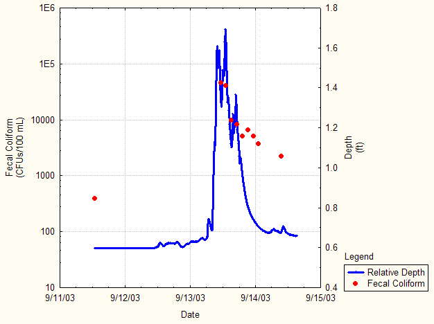
Lesson 4: Determining Schuylkill River Water Quality Using Philly RiverCast: A Daily Forecast of Schuylkill River Water Quality (Several class periods)
RiverCast Designation
USEPA Acceptable # of illnesses per 1,000 swimmers
Single Sample Maximum E. coli Concentration (cfu/100mL) Recommended by USEPA for Fresh Waters
lightly used full body contact area
infrequently used full body contact area
Green
< 9
< 410
< 576
Yellow
9 to 14
410-1783
576-2507
Red
> 14
> 1783
> 2507
Lesson 5: EMBODIED SCIENTIST PARKOUR; A field trip activity at GRAYS FERRY CRESCENT
Barkley, E. F., K. P. Cross, and C. H. Major. 2005. Collaborative learning techniques: A handbook for college faculty. San Francisco, CA: Jossey-Bass. Bruffee, K. A. 1995. Sharing my toys: Cooperative versus collaborative learning. Change 27 (1): 12-18. Flieller A, Jarlegan A, & Tazouti, Y (2016) who benefits from dyadic teacher-student interactions in the whole-class setting? The Journal of Educational Research, 109:3, 311-324, DOI 10.1080/00220671.2014.950718. To link this article: https://doi.org/10.1080/00220671.2014.950718 Garcia L, Rogat T. K., Korskey K.L (2011), Affect and engagement during small group instruction. Contemporary educational Psychology Volume 36, issue 1, January 2011, Pages 13-24 To link this article https://doi.org/10.1016/j.cedpsych.2010.09.001 Kink O. T and Boz Y., Cooperative-learning instruction for a conceptual change in the concepts of chemical kinetics, Chemistry Education Research and Practice 2012, 13, 221-236 Levine A. (2018) The History of Philadelphia’s Watersheds and Sewers Making cooperative learning work (1999). Theory into Practice 38 (2): 67-73 Meador D. Exploring (2018) The Value of Whole Group Instruction in the Classroom, article by ThoughtCo. Melamed S. (2019) Saving The Canal, The Philadelphia Inquirer Mercer E., What is Computer-Based Instruction in Education? It still works Philadelphia Water Department website Slavin, R. E. 1995. Cooperative learning: Theory, research, and practice. 2nd ed. Englewood Cliffs, NJ: Prentice-Hall. Springer, L., M. E. Stanne, and S. S. Donavan. 1999. Undergraduates in science, mathematics, engineering, and technology: A meta-analysis. Review of Educational Research 69 (1): 21-51. Pennsylvania and the Surging Sea: A vulnerability assessment with projections for sea level rise and coastal flood risk. Climate Central Research Report. pp 1-30.Bibliography (Reading List):