
This curriculum unit has three separate lessons using a drone in a high school Geometry class to bring life to some of Geometry’s classic curriculum topics: Using trigonometry to find a height, identifying polygons by their characteristics, and finding surface area and volume of solids. One of the goals is to enliven ancient methods with new technology, not to shorten the topic, but to deepen it, getting students invested in the beauty of the mathematics and perhaps discovering more about their school campus. Two of the lessons entail student teams choosing objects or sites to measure as challenges for other student teams. Student teams are involved in every aspect of the projects, including grading the other team’s work and finding the percent error. Instructions, student task sheets and rubrics are all included, as are instructions for creating a clinometer. Two types of drones are recommended: a programmable drone which operates indoors, and a drone with measuring and photography capabilities which can operate outdoors.
As a math teacher for over 40 years, I have worked to keep up with current technology. Realize, that I did not own my first calculator until I attended college as a secondary education/mathematics major. At college, my computer science course language was Basic, and we typed at a terminal in a room outside the mainframe; our program printouts were on continuous computer paper. In my career I’ve seen the introduction of desktop computers, laptop computers, 3-D printers, and many generations of graphing calculators. I’ve been trained in and used learning platforms like GeoGebra, Geometer’s Sketchpad, and Desmos. I’ve taught for years using the constructivist curriculum College Preparatory Mathematics (CPM). My current school, the Philadelphia High School for Girls has a rich history of women who worked in the birth of computers. Two of our graduates from 1942, Doris and Shirley Blumberg, were recruited by the US Army to work in a secret ballistics research lab at the University of Pennsylvania. As “human computers” they were charged with making complex ballistics tables to assist the pilots as they dropped bombs in World War II. Some of the women in this team, went on to work on the very first computer, ENIAC. Their work was documented in the film “Top Secret Rosies”. Just a few years later, another Girls’ High graduate, Milly Koss, worked with Grace Harper programming UNIVAC. She received two major awards honoring her work, an Ada Lovelace Award and a Grace Hopper Celebration of Women in Computing. Now, I am lucky enough to be taking a course in the science, engineering and operation of drones. In our class, we have learned about the structure and physics of a drone, programming a drone and the ethics surrounding drone use. A door to the whole new world of this new technology has been opened for me. Drones were first developed for military use, but according to the NextWave STEM, History of Drones in K-12 Education, recreational drones became available and were used outside of the classroom. In 2015, the cost of drones became more affordable and the technology was improved upon, so a few schools were able to incorporate them in their programs.(The History of Drones in K-12 Education I NextWaveSTEM, n.d.) At the 2016 Society for Information Technology & Teacher Education International Conference in Atlanta Georgia, professors and a graduate student from New Jersey City University, presented their recommendation that drone usage in classroom was vital to engage, motivate and inspire students to learn and grow. They developed a model of implementation, SOAR, to include safety, operation, active learning, and research. The interdisciplinary approach ensures a student-centered approach that also gives full exposure to topics pertaining to drone usage (Carnahan et al., 2016). At the 2021 3rd International Congress on Human-Computer Interaction, Optimization and Robotic Applications (HORA), Siditë Duraj, Lekë Pepkolaj and Gerald Hoxha, presented the article: “Adopting Drone Technology in Mathematics Education”. They made compelling arguments and applications on using drones in high school and university math classes. If you need to write a grant to get drones for your classroom, I highly recommend this article as a resource to convince the grantees of the merits of using drones in your classroom or school. In their introduction they contend that since math is often a challenging class for some students, why not use drone technology to solve real-life problems in various topics in mathematics to engage student and allow them to witness the results of their efforts and the power and beauty of mathematics (Siditë Duraj & Gerald Hoxha, n.d.). The authors state, “Drone technology opens a world of opportunities in school, allowing students to actively improve their understanding by integrating analytical knowledge with logic and cognitive skills. Drones have a lot to promise in this regard, as they can help students study science, technology, engineering, and math (STEM) topics in an engaging and enjoyable way.”(Siditë Duraj & Gerald Hoxha, n.d.) “Not only can drones provide key data, such as aerial images, but the operation of such a device equips students with foundational knowledge of a growing industrial technology.”(Naab & Weigel, 2021) One aspect of drones in education, which I personally am not addressing in the lessons that follow, is the US Federal Aviation Administration’s (FAA) Part 107 Commercial small Unmanned Aerial Vehicles (sUAVs) pilot test. In an article entitled “Preparing Students for Drone Careers Using Active Learning Instruction” it is noted that as drone availability and popularity grow, concerns that pilots without proper training can create threats to public safety and privacy (Lobo et al., 2021). I have included the Title 14-Aeronautics and Space Chapter 1-FAA, Department of Transportation Subchapter F-Air Traffic and General Operating Rules (Title 14-Aeronautics and Space Chapter I-Federal Aviation Administration, Department of Transportation Subchapter F-Air Traffic and General Operating Rules, n.d.)and USCODE title 49 subtitle VII part A subpartii-chap 448, §44809 Exception for limited recreational operations of unmanned aircraft (USCODE-2020-Title49-SubtitleVII-PartA-Subpartiii-Chap448-Sec44809, n.d.) in my resources.
My curriculum unit will focus on 3 topics in Geometry: Trigonometry, Area and Volume, and Polygons. The advantages of integrating drone technology into these topics covered in most Geometry curricula is for students to be motivated and engaged through hands-on practice, develop spatial visualization skills, sequencing skills, critical thinking, and soft skills, such as teamwork (Siditë Duraj & Gerald Hoxha, n.d.). The lessons will feature multiple teaching strategies and use all of the eight Standards for Mathematical Practices: 1. Make sense of problems and persevere in solving them, 2. Reason abstractly and quantitatively, 3. Construct arguments and critique the reasoning of others., 4. Model with mathematics, 5. Use appropriate tools strategically, 6. Attend to precision, 7. Look for and make use of structure, 8. Look for and express regularity in repeated reasoning (Common Core State Standards for Mathematics, n.d.) Other strategies utilized are differentiated instruction, technology based instruction, student choice, cooperative learning, inquiry-based learning, kinesthetic learning, experiential learning, reciprocal teaching and blended learning. Students will also pose Fermi type questions based on Enrico Fermi’s desire to understand order of magnitude rather than exact answers to give real meaning to a number or measure. Two different drones will be used for the lessons: the CoDrone EDU can be programmed and must be flown inside, while the DJI Mini Pro 4 has a camera, can be flown outside, and has more measuring capabilities. Before beginning the actual Geometry lessons, student teams will learn to fly the CoDrone EDU using a controller. For the first series of lessons, student teams will challenge each other to use trigonometry to find the height of various landmarks on the schools 2-acre campus. Each team will select and measure their object using the DJI Mini Pro 4 drone. The team receiving the challenge will use a clinometer to measure the angle from their line of sight to see the top of the object and measure their distance from the base of the object. Factoring in the height of the student sighting the object, they will use right triangle trigonometry to calculate the height. The second lesson will involve programming the CoDrone EDU using one of its languages, Blockly. After completing a series of programming lesson on RoboLink, CoDrone EDU’s lesson platform, student teams will create flight plans to replicate a certain polygon, using its angles, number of sides and side length. Other teams will have to determine what polygon the drone is making. For the third series of lessons, the class will use the DJI Mini Pro 4 drone to take overhead photos of the school building and campus, measuring the dimensions as it flies. The goal of the lessons will be to find the area and volume of the entire school or certain sections of the school. Students can have fun creating or answering Fermi type questions involving volume such as how many elephants could fit in the auditorium, or if you filled the gym with water, how many hippos could swim in it. Dr. Larry Weinstein, a physics professor and scholar, notes how he fell in love with Fermi in his high school physics class, posed with the classic question “How many piano tuners are there in Chicago?”(Weinstein, 2022). I’ve included in my resources, a presentation prepared by Patrick Liscio as part of the Math CoOp at Brown University on Fermi Question and Order of Magnitude (Liscio, 2019).
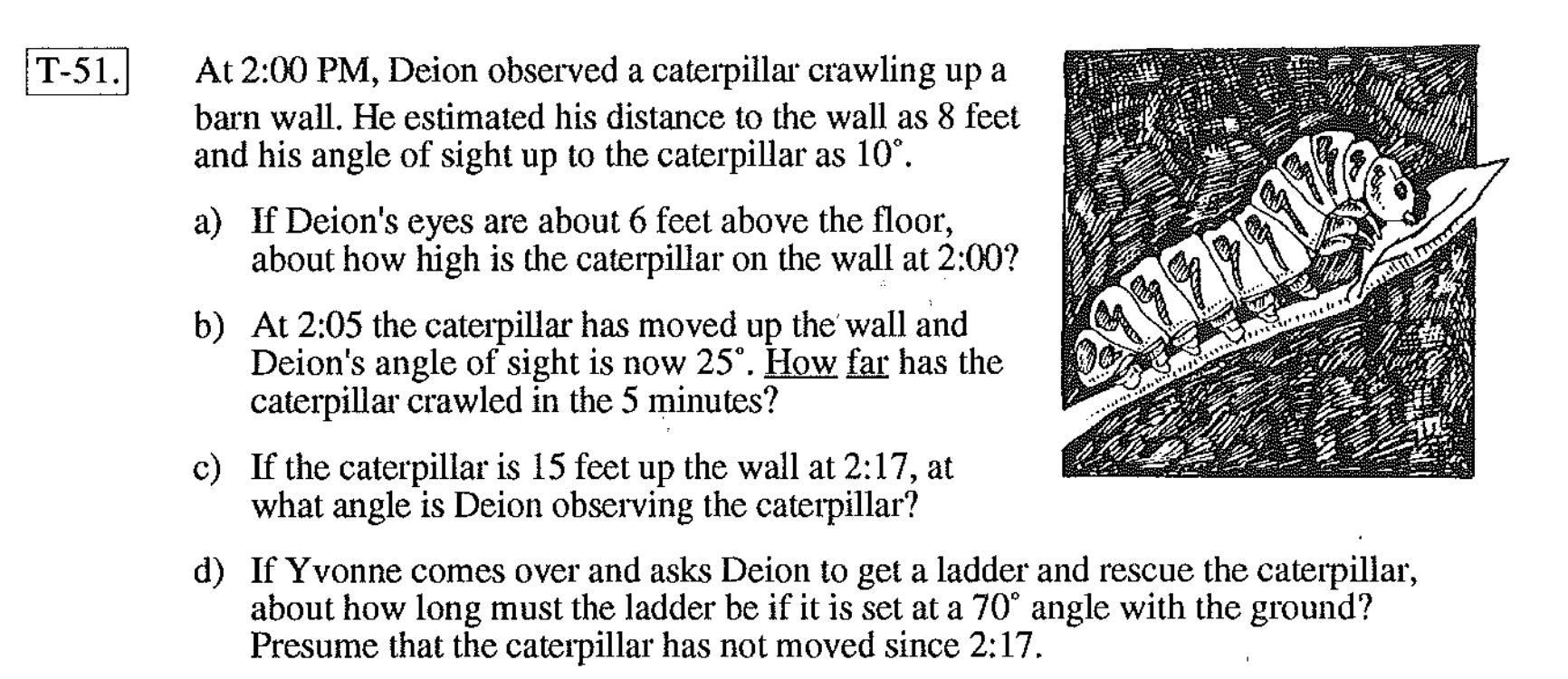
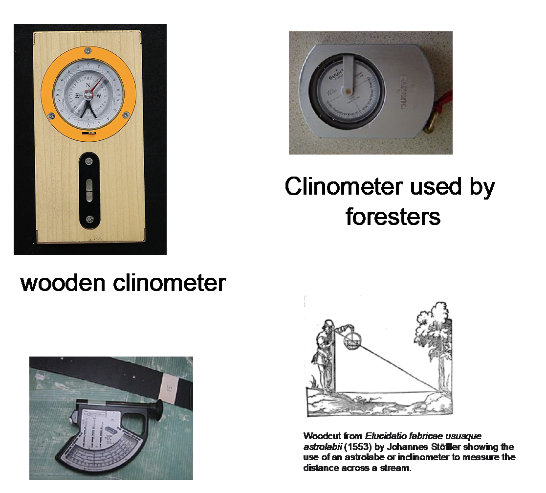
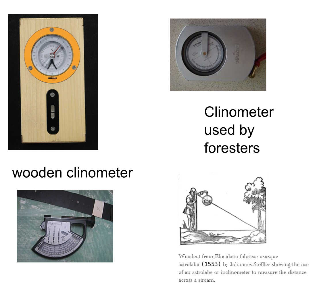
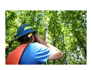
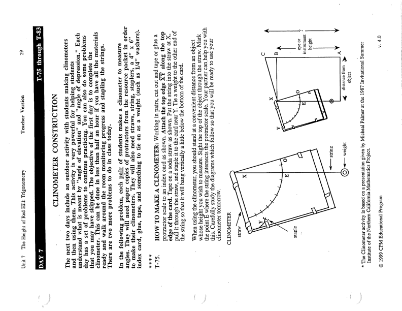
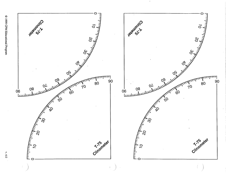
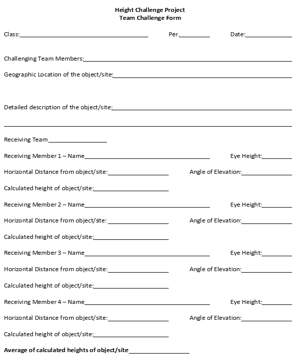
Lesson 1: Using a Clinometer and a Drone to Find Heights (1-2 weeks) Learning Objective: At the end of this lesson, students will be able to find the height of various landmarks around the school campus using a hand-made clinometer to measure angles of elevation, trigonometric equations, and a drone to check the heights. Student teams will create these “how tall?” challenges after using a drone to find the height. Materials: Prerequisites: Students have studied right triangle trigonometry and are able to use the tangent function to find a missing side. Students understand “Angle of Elevation”. Students are familiar with drone operation usage. Choosing & Measuring Challenge Site/Object – Procedures: Making a Clinometer – Procedures: At your discretion, decide if each person will be creating a clinometer or if pairs or teams of students create a clinometer to share. The Height Challenge – Procedures: Lesson 1 Notes: Lesson 1 Notes: I believe there are phone apps for clinometers, but I prefer students making and using a tangible clinometer. I don’t think you would lose too much from the lesson though by using an app. It would save a day or two from the total lesson time. Lesson 2: Programming the CoDrone EDU Drone with Blockly for Robolink (1-2 weeks)* * The time allotment for this lesson will depend upon how prepared your students are to use a programming tool and how familiar they are with the CoDrone EDU drone. Lesson Objective: At the end of this lesson, students will be able to operate the CoDrone EDU using the controller. Students will be able to program a CoDrone EDU using Blockly for Robolink to demonstrate various polygons using drone flight. Students should already be familiar with the properties and characteristics of polygons. Materials: Procedures: Lesson 2 Notes: Robolink also provides teacher resources that include premade lessons. The lessons include articles and videos about the topic as well as code for programs. They also note the standards and offer an evaluation. I highly recommend investigating the lessons and modeling your own lessons on them. Lesson 3: Real Dimensions for Hands-On 2-D & 3-D Measures (3-5 days) Learning Objective: At the end of this lesson, students will be able to find the area and volume of the school building(s) and other parts of campus by using drone measurements and photographs to find dimensions. Student teams will then create problems of capacity using non-standard units of measure. Materials: Procedures: Lesson 3 Notes: One of the purposes of using non-standard units of measure is for students to develop a sense of magnitude when discussing the area and volume of parts of the school and its campus. This should also be a project that allows students to have fun while completing a real-world task.
Carnahan, C., Crowley, K., Hummel, L., & , L. S. (2016). New Perspectives on Education: Drones in the Classroom. Proceedings of Society for Information Technology & Teacher Education International Conference 2016. Common Core State Standards for Mathematics. (n.d.). Liscio, P. (2019). FERMI QUESTIONS AND ORDERS OF MAGNITUDE. https://www.dam.brown.edu/math-coop/presentations/Fermi.pdf Lobo, D., Patel, D., Morainvile, J., Shekhar, P., & Abichandani, P. (2021). Preparing Students for Drone Careers Using Active Learning Instruction. IEEE Access, 9. https://doi.org/10.1109/ACCESS.2021.3110578 Naab, S., & Weigel, E. (2021). A Bird’s-Eye View of Using Drones in the Classroom. American Biology Teacher, 83(6), 407–410. https://doi.org/10.1525/abt.2021.83.6.407 Siditë Duraj, st, & Gerald Hoxha, st. (n.d.). Adopting Drone Technology in Mathematical Education. https://doi.org/10.1109/HORA52670.2021.9461297 The History of Drones in K-12 Education I NextWaveSTEM. (n.d.). Retrieved November 10, 2023, from https://nextwavestem.com/stem-resources-news/historyofdronesineducation Title 14-Aeronautics and Space Chapter I-Federal Aviation Administration, Department of Transportation Subchapter F-Air Traffic and General Operating Rules. (n.d.). USCODE-2020-title49-subtitleVII-partA-subpartiii-chap448-sec44809. (n.d.). Weinstein, L. (2022). Question 1: Space telescope; Question 2: JWST2. The Physics Teacher, 60(5), 390–391. https://doi.org/10.1119/10.0010399 eCFR :: 14 CFR Part 107 — Small Unmanned Aircraft Systems (FAR Part 107). (n.d.). Retrieved December 12, 2023, from https://www.ecfr.gov/current/title-14/chapter-I/subchapter-F/part-107 Abichandani, P., Iaboni, C., Lobo, D., & Kelly, T. (2023). Artificial intelligence and computer vision education: Codifying student learning gains and attitudes. Computers and Education: Artificial Intelligence, 5, 100159. https://doi.org/10.1016/J.CAEAI.2023.100159 Ahmed, H. O. K. (2021). Towards application of drone- based GeoSTEM education: Teacher educators readiness (attitudes, competencies, and obstacles). Education and Information Technologies, 26(4). https://doi.org/10.1007/s10639-021-10475-6 Chou, P.-N. (n.d.). Smart Technology for Sustainable Curriculum: Using Drone to Support Young Students’ Learning. https://doi.org/10.3390/su10103819 Dan June Nier, R., Norida Wahab, S., Daud -, D., Zahir, H., Fathi, M., Tharima -, A., Jacobs, D. C., Burba, J., Bowman, J. D., -, al, & Hyunjin, C. (2021). You may also like A Qualitative Case Study on the Use of Drone Technology for Stock Take Activity in a Third-Party Logistics Firm in Malaysia Strategic framework of using drone in cities disaster response First Demonstration of ECHO: an External Calibrator for Hydrogen Observatories This content was downloaded from IP address 100 A Study on the Utilization of Drone Education in the Fourth Industrial Revolution. 12017. https://doi.org/10.1088/1742-6596/1875/1/012017 Espinola, J. D. P., Ignacio, J. E. D., Lacaden, J. P. L., Toribio, C. B. D., & Chua, A. Y. (2019). Virtual simulations for drone education of senior high school students. International Journal of Engineering and Advanced Technology, 8(6 Special Issue 3). https://doi.org/10.35940/ijeat.F1036.0986S319 Farr, V., & Light, G. (2019). Integrated STEM Helps Drone Education Fly. 2019 9th IEEE Integrated STEM Education Conference, ISEC 2019. https://doi.org/10.1109/ISECon.2019.8881958 Lesičar, J. Ć., & Božić, D. (2021). CURRENT STATUS OF THE USE OF DRONES IN EDUCATION IN CROATIA. Interdisciplinary Description of Complex Systems, 19(1), 160–167. https://doi.org/10.7906/indecs.19.1.13 Shui Ng, W., & Cheng, G. (2019). Integrating Drone Technology in STEM Education: A Case Study to Assess Teachers’ Readiness and Training Needs. Issues in Informing Science and Information Technology, 16, 061–070. https://doi.org/10.28945/4288 Weinstein, L., & Edwards, P. (2013). Guesstimation 2.0. Princeton University Press. https://doi.org/10.1515/9781400844661Additional Resources
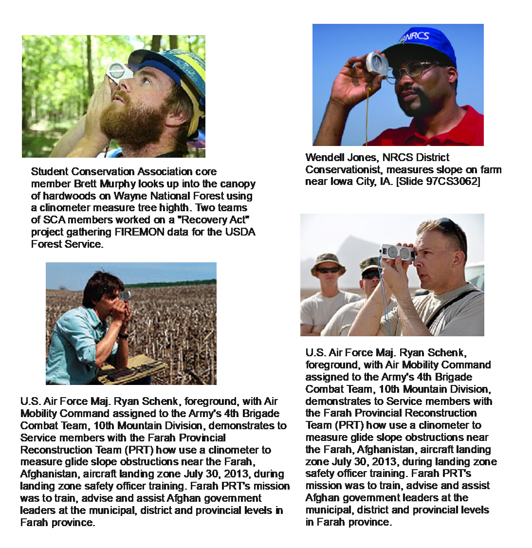
From the Common Core State Standards for Mathematics Congruence G-CO Make geometric constructions Similarity, Right Triangles, and Trigonometry G-SRT Define trigonometric ratios and solve problems involving right triangles Geometric Measurement and Dimension G-GMD Visualize relationships between two-dimensional and three- dimensional objects Modeling with Geometry G-MG Apply geometric concepts in modeling situations © CPM Educational Program 2024. All rights reserved. Used with permission. Which One Doesn’t Belong? Student Conservation Association core member Brett Murphy looks up into the canopy of hardwoods on Wayne National Forest using a clinometer to measure tree height. Two teams of SCA members worked on a “Recovery Act” project gathering FIREMON data for the USDA Forest Service. © CPM Educational Program 2024. All rights reserved. Used with permission. CPM Math 2 (Geometry) © CPM Educational Program 2024. All rights reserved. Used with permission Height Challenge Project We have studied Right Triangle Trigonometry and used it to find missing sides and angles of right triangles from given problems and in application. This project is to find heights of various objects or sites on our school’s campus. You will work with a team to create and solve a height challenge. Each student should have the permission slip signed and returned by the second day of the project. Height Challenge Rubric Student Per. Team Height Challenge Reflection For this project you have: Answer the following questions with as much detail as possible. How Big is Our School? Measurement Project We have studied area and volume and used our knowledge to find capacity measures for various polygons and polyhedral. You have also walked these hallowed marble halls and to and from our campus over 200 times. This project will ask you to combine your academic knowledge to the specifics of our school. You will work with a partner or your team to use drone photographs to find the area and volume of rooms or sites in our school and on our campus. How Big is Our School? Measurement Project Grading Rubric Students Per Team
paper folding, dynamic geometric software, etc.).
![]()
Task
Possible Points
Earned Points
Notes
Challenger:
1
Height challenge object/site selected
10
2
Height challenge object/site measured accurately with drone
20
3
Height challenge percent error calculated accurately
10
Calculator:
4
Clinometer constructed accurately
15
5
Height challenge object/site measurements made accurately (angle of elevation and horizontal distance)
20
6
Height challenge object/site calculated accurately
10
7
Percent Error Points:
0-5%
15
6-10%
10
11-25%
5
26-50%
2
8
Completed reflection questions thoughtfully
5
Total Points
100
Task
Possible Points
Earned Points
Notes
1
Site selected on time
10
2
Accurate measurements acquired
15
3
Accurate calculations of capacity made
20
4
Fermi-type question posed with correct answer calculated and given
25
5
Posed Fermi-type question calculated accurately
30
Total Points
100