
This unit is created for a 9th grade physical science class and aims to integrate freshwater ecology and urban studies. People often dissociate densely packed urban areas and the more traditional sense of nature when in fact, the two are very intertwined and influence one another. Ecology is the study of the relationship between organisms and their physical environment both natural and man made. Though the city is not filled with the traditional sense of nature, the man made surroundings and the organisms that interact within it are just as important. This unit asks students to answer thought provoking questions such as; how does the city affect our natural resources? How does the social role humans play influence the urban ecological system that now exists? The tidal Schuylkill and Delaware river provides a natural resource for students to research how a river can influence a city as how the city influences a river and how these relationships change over time In addition to the content standards, this unit is geared towards teaching students how to communicate scientific information in order to evoke community change as well as environmentalism via the arts.
In the modern science classroom, it is easy to keep students engaged. Students love the many labs and hands-on activities that science offers. However, providing meaningful connections to low income urban students lives and real-world uses is an enormous challenge. Kensington Creative and Performing Arts High School is a small high school in North Philadelphia. The student population is 60% Latino, 27% African American, 10% Caucasian and 3% Asian or other with 100% of the student population economically disadvantaged. In an urban environment, it is very easy for students to dissociate the natural components of environmental sciences from their life as they do not live in a suburban or rural area. The separation of city life and natural life could be eliminated by education. Students in urban environments have natural components and create new ecosystems that are directly influenced by human activity in philadelphia. Beginning by defining the boundaries of a river throughout history and across cultures this unit looks at the natural resources Philadelphia was built around. These resources include the Wissahickon Creek, Schuylkill River, and the Delaware River which are all within a short bus ride from their school. Students can directly investigate interactions among biotic and abiotic factors within the Schuylkill River. Their investigations allow them to explain how surrounding resources give an ecological community its basic structure as well as how these communities both natural and human are maintained and developed. This unit was made intended for a 9th grade General Science class that meets every other day for 90 minutes. It contains 5 lessons to be taught over the course of two weeks with a culminating project at the end that involves community outreach. Depending on the magnitude of project desired by the teacher the lessons can be extended or taught throughout an ecology or environmental unit. BIO.B.4.1.1 Describe the levels of ecological organization (i.e., organism, population, community, ecosystem, biome, and biosphere). SWBAT Understand the concept and components of a watershed and be able to identify stream orders and watershed boundaries IOT Know the features of a healthy watershed and an unhealthy watershed SWBAT interpret water and biological quality tests IOT understand why aquatic organisms and water quality is affected by the physical, chemical and biological conditions of the water and how it impacts aquatic environments. SWBAT Understand the dependence of all organisms on one another IOT show energy and matter flow within an aquatic ecosystem. SWBAT create, organize and carry out a plan to educate their peers or community surrounding nature in Philadelphia IOT evaluate and reflect on circumstances or issues that would prompt them to evoke change in their school or neighborhood. Ecologically, a river can be broken down into five main components. It starts at a source or headwater which are usually underground springs or fed by mountain snow then flows into a channel which is the course the river carves along the landscape. Tributaries are smaller rivers or streams originating from a lake or other water source that flows into and becomes a part of the main river. The mouth or delta is the end of the river where it flattens out and fans leading into a lake, ocean or wetland. The river channel is the course that the river takes along the landscape between two river banks, and traditionally what comes to mind when one things of a river. The river however also extends into the floodplains the land area next to the river which flood from time to time when the water is high (What Makes a River 2017). In metropolitan areas the floodplain is often eliminated with stone walls along the riverbank however with rising sea levels and strong hurricane forces, nature can easily re-define these boundaries. The Delaware river originates from two main branches in the Catskill mountains in New York state. Flowing downstream the river forms the boundary between Pennsylvania and New York then Pennsylvania and New Jersey. The river flows 419 miles into the Delaware bay then into the Atlantic Ocean. The Schuylkill river is a tributary of the Delaware originating near Pottsville in the Anthracite Coal Region. The water in the Schuylkill travels 135 miles to Philadelphia where is flows into the Delaware (National Hydrography Dataset 2012). Both the Schuylkill and the Delaware river are tidal rivers throughout Philadelphia meaning their flow and level are influenced by the tides of the Atlantic ocean. The Delaware and Schuylkill Rivers were instrumental in the economic and social development of the Mid-Atlantic region. The Schuylkill and Delaware Rivers remained an important thoroughfare for shipping throughout the mid 20th century. Many factories, shipping facilities and ports were built along the rivers as a result. Due to the economic success of the city, Philadelphia itself was built on what once was wetlands. These wetlands were dredged to form shipping canals and filled to build expansions of the city such as South Philadelphia and the airport (Cantanese 2015). Not only were the wetlands filled in, but many streams and small tributaries were diverted or combined under the streets to make room for houses and industry (Levine 2018). In the anticipation of the effects of global warming, sea level rises threaten many areas of Philadelphia with flooding especially the areas built on former wetlands and streams (Surging Seas 2019). With the rise of urban areas in the world there also rises a new classification of what an ecosystem includes. An ecosystem is a biological community of interacting organisms and their physical environment (Merriam Webster 2019). When studied in school it is most often paired with the study of biomes, the naturally occurring flora and fauna occupying a major habitat e.g. desert, forest, and tundra. Limiting natural phenomena to uninhabited areas can block students from understanding that nature is not limited to suburban or rural areas. Natural processes as well as vivacious ecosystems occur everywhere and anywhere. However confining a city landscape to the predetermined ‘natural’ formulas does not fit and discounting nature in an urban area leads to the misconception that if there is no nature, respect for the natural features that are there need not be given (Cronon 2004). The Anthropocene is a proposed epoch in geological time defined as the period which humans have been the dominant force on climate and the environment. Humans are not only the driving force of urbanization but also the new driving force of nature. Unlike traditional rural forest landscapes, the buildings and urban infrastructure are instrumental in an ecosystem’s structure and function within cities (Grove et al. 2006). Philadelphia is a dense city built in the 17th and 18th centuries with thin roads with very little space for trees and other vegetation. The infrastructure within Philadelphia may be a hindrance to ecological growth, but that does not stop nature from thriving. There is not yet a single event to signify the beginning of the Anthropocene, however the evidence of the change in epoch is overwhelming. As far as 3000 years ago soil began showing signs of human activity through widespread fertilizer use (Doucet, et al. 2012). Industrialization lead to increased carbon dioxide in the atmosphere accelerating the global warming process. Recent effects include increase in average global temperature, melting ice caps, and acidification of the ocean to name a few. These changes in climate cause widespread destruction not only in ecosystems of the forest and tundra, but in towns and cities as well .Problem Statement
Unit Objectives
PA Standards
4.4.10.B: Analyze the effects of agriculture on society’s economy, environment, standard of living, and foreign trade.
4.4.10.C: Analyze how agricultural sciences and technologies strive to increase efficiency while balancing the needs of society with the conservation of our natural resources.
4.1.10.B Explain the consequences of interrupting natural cycles.
4.1.10.E Analyze how humans influence the pattern of natural changes in ecosystems over time.
4.4.12.D: Describe how policies, regulations, and laws affect the technologies adopted in agriculture.
4.4.12.E: Judge that conclusions are consistent and logical with experimental conditions.
BIO.B.4.1.2 Describe characteristic biotic and abiotic components of aquatic and terrestrial ecosystems.
BIO.B.4.2.2 Describe biotic interactions in an ecosystem (e.g., competition, predation, symbiosis).
BIO.B.4.2.3 Describe how matter recycles through an ecosystem (i.e., water cycle, carbon cycle, oxygen cycle, and nitrogen cycle).
BIO.B.4.2.4 Describe how ecosystems change in response to natural and human disturbances (e.g., climate changes, introduction of nonnative species, pollution, fires).
BIO.B.4.2.5 Describe the effects of limiting factors on population dynamics and potential species extinction.Content Objectives
Anticipatory set – establish a link between what the students know about the topic before the topic is introduced. This promotes a framework in the students to put the topic in context with their previous knowledge. Anticipatory sets are also used to engage students with actions and statements to relate the experiences of the students to the objectives of the lesson. Cooperative Learning – Small groups comprised of students with different levels of ability to work together to improve their understanding of the content. Field Trip – involvement in experiences outside the classroom as a supplement to learning enable students to extend what is being learned in the classroom to the real world Graphic organizers A graphic organizer is a visual and graphic display that depicts the relationships between facts, terms, and/or ideas within a learning task Matching – An alternative to a traditional vocabulary quizzes and traditional formative assessments involved having cards with words, definitions and pictures. Students can then work individually or in small groups to correctly match related cards. Probing Questions – Probing questions are a tool used to guide students to the answer themselves instead of out-right telling them the answer. Quick Write – quick writes are an educational tool used in this unit as a brain break and to engage previous knowledge about the topic.. The student is given a question and asked to write uninterrupted on that topic. After a quick write the teacher can check the answers or ask students to share. For more information about using quick writes and additional total classroom participation techniques in the classroom visit http://www2.beth.k12.pa.us/esol/downloads/TotalParticipation.pdf Ripple – The ripple involves students pairing up and sharing their ideas in sets of two, four, then the whole class. This allows students who are less inclined to share with the whole class share their ideas individually. It can also allow the teacher to gauge where students who are less comfortable to share out in a whole group setting are in their learning. (Persida Himmele, 2017) For a brief description of how to use the ripple in the classroom visit https://thecornerstoneforteachers.com/truth-for-teachers-podcast/total-participation-techniques/ Rubrics – Rubrics are key to guide students in understanding what is expected of them in the classroom, as a small group, and individually. Rubrics will be used in this unit for students to keep track of the teacher’s expectations, learning outcomes and what to include in their project. Timing/timers – The use of timers is a personal preference in the classroom. General timing guidelines are useful to keep the classroom focused on the parts of the lesson that are most important and limiting the amount of time the class is ‘teacher centered’ instead of ‘student centered.’ Timers can also be used to keep students focused on the task at hand. Projecting timers can assist students in time management keeping them focused on the task at hand. Based on the teacher’s professional observations, more or less time can be attributed to any given activity depending on student engagement and classroom dynamic. Visuals – Visual cues is important to enhance student learning especially when teaching new vocabulary. Vocabulary is extremely important in this unit, using images and other visuals can stimulate the brain in new ways, increase memory and develop understanding. Word Map – (Schwartz & Raphael, 1985; example from Holder, 1997) The word map technique is useful for helping students develop a general concept of definition. It focuses on three questions, “What is it?,” “What is it like?,” and “What are some examples?” to make students aware of the types of information that make up a “definition” and how that information is organized. Whole Group/Direct Instruction – in different sections of the unit the teacher will be required to instruct the class as a whole to relay information about origami and its applications in various fields of study. Direct Instruction is often used in conjunction with PowerPoint presentations or Lecturing.
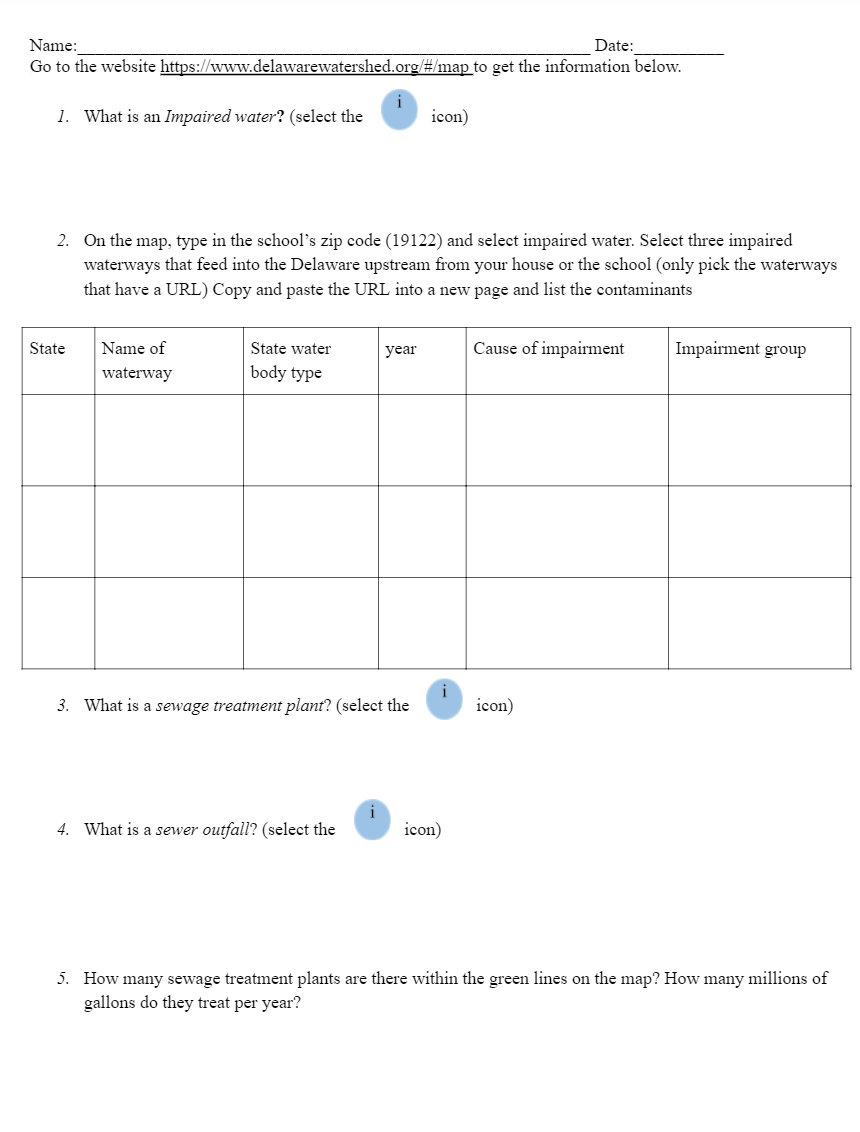
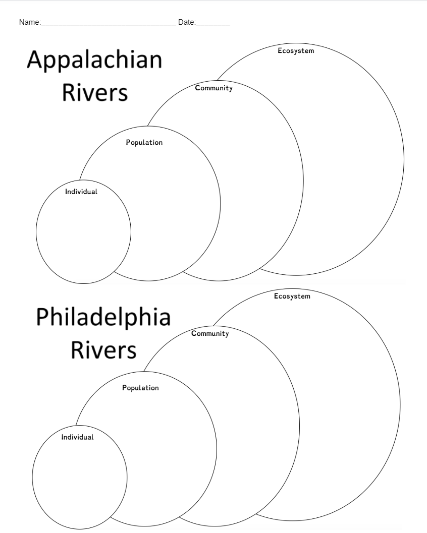
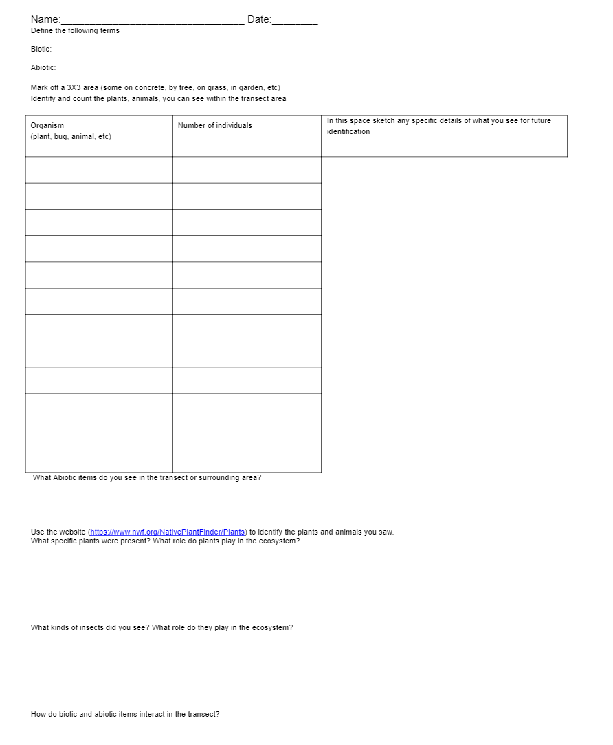
SWBAT Understand the concept and components of a watershed and be able to identify stream orders and watershed boundaries IOT Know the features of a healthy watershed and an unhealthy watershed This lesson is meant to be taught during or after lessons on the water cycle. The purpose of this lesson in particular is to introduce river systems specifically rivers in Philadelphia. Emphasis should be given to show rivers in the city are just as much connected to the natural world as rivers in national forests. The water that flows in our streets (and the garbage) goes back into the cycle. Do Now (10 minutes) Where is water in Philadelphia? Where is the water from Philadelphia from? – Teacher should facilitate a discussion addressing the misconception that water is only found in rivers lakes and oceans. Water is all around us in different states (especially when it rains) Activity 1 (25 minutes) Matching activity for vocabulary enhancement and ESL support, have students match the words to the definition and a picture in pairs. (see Activity Sheet 1) After the teacher has checked that the words definition and picture are labeled correctly, the teacher may pick two terms in the water cycle and have the students write a short paragraph explaining how the two processes are related to each other and important to the water cycle. This should be completed while other students are finishing. Activity 2 (45 minutes) River – Anatomy of a River https://www.nationalgeographic.org/encyclopedia/river/ Either online or printed out students can read the national geographic article and define the following terms. The article continues past Anatomy of a river into rivers through history by continent and pollution. For the purposes of this activity only one section is needed however more sections can be used as extensions at the teacher’s discretion Important Vocabulary Terms River Bed – the bottom part of a river Source – beginning of river Channel – the deepest parts of a river Mouth – area where the river opens up into the sea or ocean Floodplain – flat area next to the river that floods Tributaries – small streams that flow into the main river Watershed – Area of land that separates waters flowing to different rivers, Estuary – section of a river meets the sea where the tide flows in causing fresh and salt water to mix Exit Ticket (10 minutes) On a projector, smart board, or printed out show a picture of the Delaware river watershed. An interactive map can be found at http://www.phillywatersheds.org/your_watershed/schuylkill/interactive_map and https://www.schuylkillwaters.org/resources/watershed-map Using the vocabulary terms defined in the article have the students label the different parts of the Delaware river. SWBAT interpret water and biological quality tests IOT understand why aquatic organisms and water quality is affected by the physical, chemical and biological conditions of the water and how it impacts aquatic environments. Many students have not interacted with the Delaware or Schuylkill river before or not know how humans impact the river. This lesson is designed to show students how without knowing it we indirectly interact with the river every day and it is not ‘they’ who are damaging it is ‘we.’ Where does Philly water come from? Who uses the river? Who is responsible for the river? What do we use the river for? Activity 1 (50 mins) Using the website https://www.delawarewatershed.org/#/map students can complete Activity Sheet 2 Discussion (25 minutes) Discuss with the students their thoughts use guiding questions such as, does our use of the river change the river? Is it only Philadelphia who is responsible for the river? It is important for students to understand the Delaware river is not just Philadelphia’s responsibility is it a composite of every other river that exists and every input along the way. The inputs change along the way (farming, coal mining etc) but each input changes the river. Here the teacher can introduce the vocabulary term Eutrophication – everything in water is an energy input. Where does the energy input? Does it matter where? Is one place better than another? When you study a river you can’t just look at one part, it is moving so you have to look at all parts at once. How does this input change the ecosystem? This can be presented in discussion format as a ripple or quick write to express the student’s thoughts Exit Ticket (5 minutes) What are some ways you either directly or indirectly interact with the river? SWBAT Understand the dependence of all organisms on one another IOT show energy and matter flow within an aquatic ecosystem. This lesson is designed to be taught as an introduction notice nature, notice non nature, notice ecological systems. Many people in the city consider nature as a place that exists in the suburban or rural areas however it exists all over the city in the river and otherwise. The respect we have for nature in the forest should and could be translated into the city. How do you think the ecosystem of a river changes at the source of the Delaware watershed to Philadelphia? Activity 1 Using Activity Sheet 3 students can draw what they think the ecosystem in the river looks like at each level in the Appalachians vs in Philadelphia. At this point each student can present or participate in a gallery walk to show what they think the similarities and differences are between ‘nature’ and ‘city’. When completed students should discuss if there is nature in the city. If so what is it? At which level do the changes take place? Activity 2 Use Activity Sheet 4 to complete a transect study of a small area of land. Transect studies are used to record occurrences of individuals in a certain area. This activity is possible to do in the school yard however it is preferable to be in a park with varied plant and animal life. This is also an opportunity to take a walking trip to the Delaware or Schuylkill rivers. For this particular activity I will be taking my class to Penn Treaty Park about a 20-minute walk and along the Delaware River. It is encouraged that students take pictures of all the plant and animal life they see big or small. These photos can be printed out as an art project or used for identification purposes. SWBAT create, organize and carry out a plan to educate their peers or community surrounding nature in Philadelphia IOT evaluate and reflect on circumstances or issues that would prompt them to evoke change in their school or neighborhood. Breaking down the walls between nature and city is an important lesson for respecting the environment. It is important for students to take what they learned and apply it. The final lesson of the unit is going to require the students to take what they’ve learned and create a solution or start an awareness campaign around the school or their neighborhood. What harms nature? What helps nature? Activity 1 Discuss with students that although the river experienced a lot of harm there are many solutions and today they are going to be brainstorming in groups an actionable steps to support a healthy Philadelphia ecosystem including plants, animals, humans and buildings. My class will be expressing this eco-activism through art projects. As a class or individually introduce how artists, environmentalists and scientists are raising awareness specifically focusing on bridging the gap between urban and rural. http://schuylkillcorps.org/ – Has information about local artists using different mediums including sculptures, oral histories, photographs and historical collections of the Schuylkill river. https://www.pwdraincheck.org/en/stormwater-tools/rain-barrels – Offers free rain barrels to reduce water consumption. Could be installed in schools or in neighborhoods. https://www.schuylkillbanks.org/projects– A catalogue of future and past projects along the Schuylkill river banks https://hiddencityphila.org/2014/06/how-can-you-know-what-it-means-to-be-here/ – Includes poetry and local art pieces (in the store section) about the Schuylkill river. https://inhabitat.com/philadelphias-magic-garden-is-a-mosaic-of-recycled-materials/ – Brief overview of recycled material mosaic found throughout Philadelphia https://www.muralarts.org/ – mural arts program uses murals to unite communities and provide many opportunities for art to be displayed around the city History of the Schuylkill river The following links provide content relating to the history of the Schuylkill and the Delaware rivers. This includes historical pictures, artifacts and environmental changes. https://www.schuylkillbanks.org/history http://www.paenvironmentdigest.com/newsletter/default.asp?NewsletterArticleID=3855&SubjectID= Ecological resources The following are a few sites that focus on the ecology and environment of watersheds in and around Philadelphia. https://ansp.org/research/environmental-research/sections/watershed/ http://watersheded.dcnr.pa.gov/studying/ Interactive maps – The following websites are websites that provide interactive maps that can help students visualize ecological data on a local and national scale https://viewer.nationalmap.gov/advanced-viewer/ http://www.phillywatersheds.org/your_watershed/schuylkill/interactive_map
Lesson One: Introduction to Water in Philadelphia
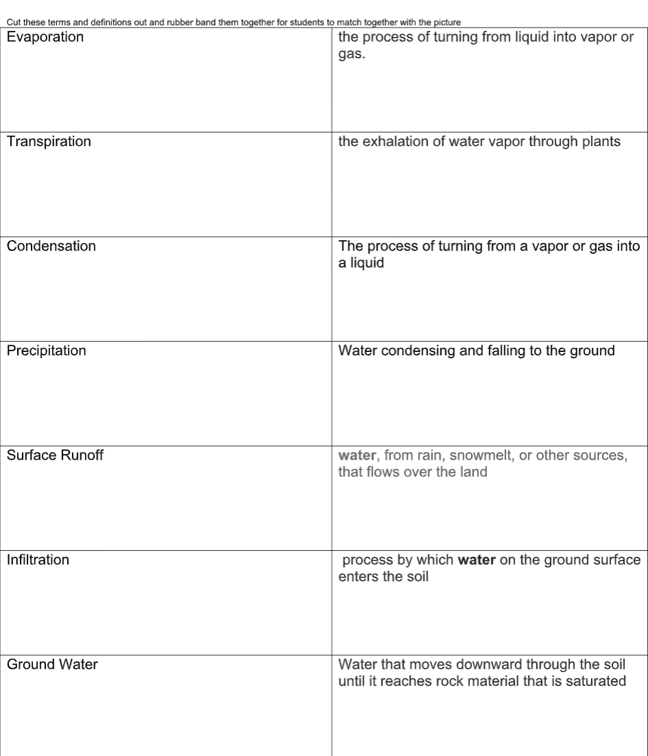
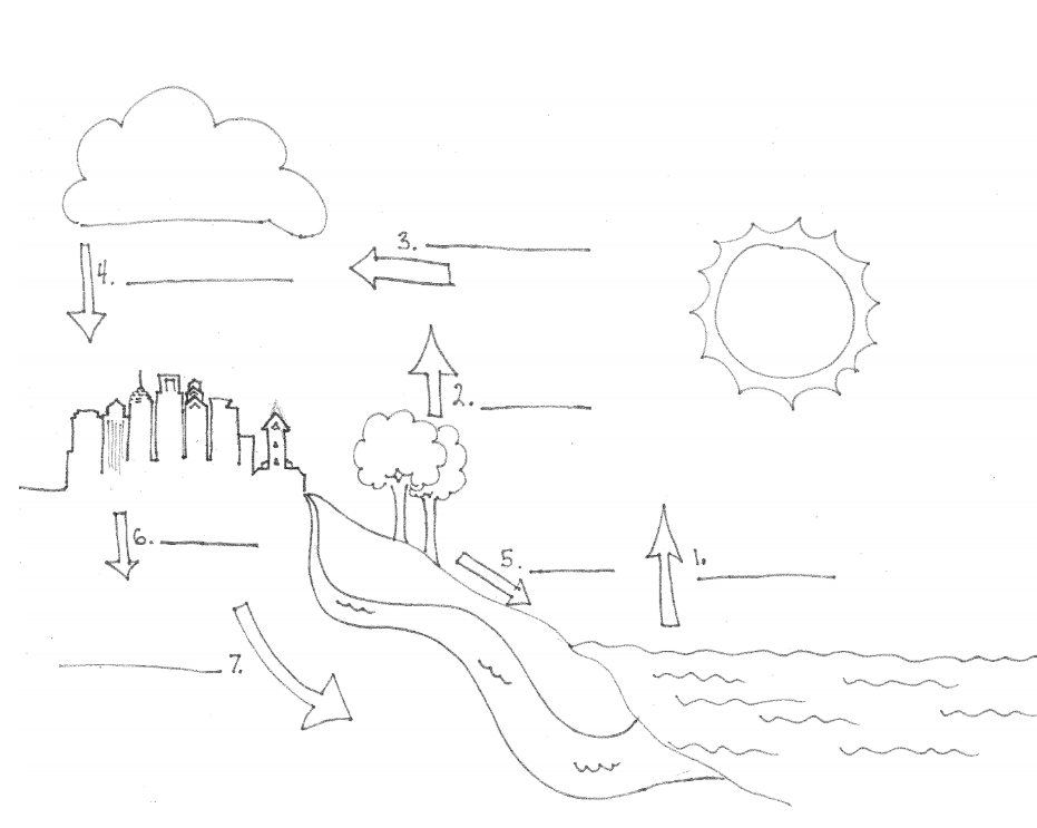
Students should have learned about the water cycle before. picture of water cycle and they can put the words and definitions where the terms sit in the water cycle (or solid liquid gas phase)
Activity Sheet 1
Lesson Two: How does Philadelphia use the river?
Do Now (10 Minutes)
Activity Sheet 2
Lesson 3 and 4 The City Is Natural
Do Now
Activity Sheet 3
Activity Sheet 4
Lesson 5 Now what
Do Now:
Additional Resources for Project Planning
Cantanese, Cristina. “Wetlands and WetLand in the City.” Schuylkill Center for Environmental Education, Schuylkill Center, 19 Jan. 2015, www.schuylkillcenter.org/blog/wetlands-and-wetland-in-the-city/. Cronon, W. The Trouble with Wilderness. Shiplee, B, 2004. “Ecosystem.” Merriam-Webster, Merriam-Webster, www.merriam-webster.com/dictionary/ecosystem?utm_campaign=sd&utm_medium=serp&utm_source=jsonld.. Grove, J.M., Troy, A.R., O’Neil-Dunne, J.P.M., Burch, W.R., Cadenasso, M.L., Pickett, S.T.A., 2006. Characterization of households and its implications for the vegetation of urban ecosystems. Ecosystems 9, 578e597 Himmele, W. H. (2017). Total Participation Techniques: Making Every Student an Active Learner, 2nd ed.Alexandria, VA: ASCD Levine, Adam. “The History of Philadelphia’s Watersheds and Sewers.” Philly H2O: Hidden Streams 1889, 16 May 2018, www.phillyh2o.org/backpages/HiddenStreams_1889.htm. “Surging Seas Sea Level Rise Analysis by Climate Central.” Surging Seas: Sea Level Rise Analysis by Climate Central, Climate Central, sealevel.climatecentral.org/. “The Anthropocene | Welcome.” Edited by Anne-Marie Hauge Doucet et al., Welcome to the Anthropocene, Commonwealth Scientific and Industrial Research Organization (CSIRO), Globaïa, International Geosphere-Biosphere Programme (IGBP), International Human Dimensions Programme on Global Environmental Change (IHDB), Stockholm Resilience Centre and Stockholm Environment Institute., 2012, www.anthropocene.info/. U.S. Geological Survey. National Hydrography Dataset high-resolution flowline data. The National Map Archived April 5, 2012 “What Makes a River?” American Rivers, 2017, www.americanrivers.org/rivers/discover-your-river/river-anatomy.